
Space satellite remote sensing
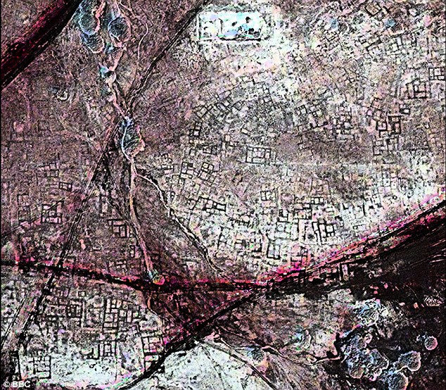
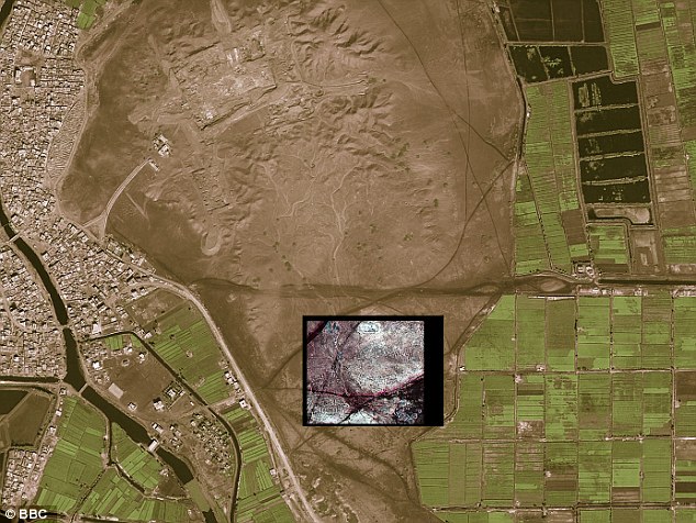
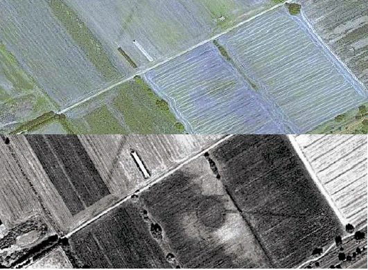
A satellite image before and after further processing to aid interpretation
Dr Sarah Parcak has been something of a pioneer in the application of space satellite remote sensing technologies to archaeological studies.
Operating in close co-operation with many highly qualified colleagues she has been involved in helping to bring to light many interesting and exiting finds.
It would probably be inappropriate to describe the findings as - Dr Sarah Parcak discoveries - as such. She would doubtless herself be the first to concede that such findings actually result from team efforts, nevertheless she has generally functioned as a lead figure within the teams of researchers.
She the author of an influential textbook entitled 'Satellite Remote Sensing for Archaeology' (2009).
Some of the source articles consulted in preparing this article give credit to Dr Sarah Parcak personally for important refinements in how space satellite remote sensing imagery can be better interpreted.
A few sentences on a National Geographic web page for example, read as follows:-
Through "thousands of hours" of trial and error she has perceived what the human eye can't. Hard-won successes have taught her what works: combining and processing images so she can
peer into the infrared part of the light spectrum, which is invisible to the naked eye. The images allow her to detect subtle surface changes caused by objects like mud bricks a
foot or less underground.
Dr Sarah Parcak, in co-operation with teams she has been significantly involved in, has shared in the responsibility for making many interesting and exciting discoveries. A brief consideration of a few of these now follows.
Itj-tawy
Cairo has not always been the capital of Egypt. Thebes, for example, is quite widely known-of as being the Egyptian capital city under some of the Pharaohs.It has happened that historical relocations of the chief city of Egypt are actually attributable to changes over time in the main course, or of the branches, of the river Nile.
Extensive settlements that had been easily serviced in terms of administrative communication, and of the supply of necessities, by use of the waters of the Nile system when they flowed nearby could find themselves somewhat isolated when the Nile underwent dramatic changes in its course.
A city known as Itj-tawy functioned as the Egyptian capital over several centuries.
As Sarah Parcak puts it herself:-
"Itj-tawy was ancient Egypt's capital for over four hundred years, at a period of time called the Middle Kingdom about four thousand years ago. The
site is located in the Faiyum of Egypt, and the site is really important because in the Middle Kingdom there was this great renaissance for ancient Egyptian art,
architecture and religion."
After being abandoned largely as a result of a branch of the Nile changing its course, knowledge of the actual siting of the formerly great city of Itj-tawy had been lost.
The best estimates of conventional scholarship believed that they could place the location to being within an area four miles by three, this rather extensive area offering possibilities of situation thought to be suitable due to the proximity to two pyramids which served as tombs of the two kings responsible for building of Itj-tawy.
Dr Sarah Parcak, and the team she was involved with, aimed to make discoveries as to where the Nile used to flow in order to give better focus to their intended search of Itj-tawy.
Space satellite remote sensing technologies helped to place the course of the Nile during the relevant centuries of the Middle Kingdom period as being significantly, that is to say eight kilometers, to the west of its present-day course.
It was often the case that ancient settlements, whether or not they were originally situated on elevated sites, became raised up in elevation when they were occupied for protracted periods of time as materials brought onto the site found a long-term home there rather than being hauled away when they had fulfilled their purposes.
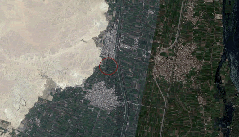
The research team, bearing in mind the location of the two pyramids, used the ancient water line as a guide and considered that a large raised area in the circle above should be regarded as being of potential significance.
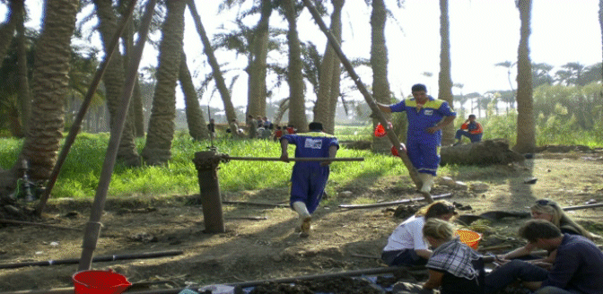
The teams' conjectures were followed by Dr Sarah Parcak seeking a collaboration with Egyptian scientists to do "coring" at this site.
Tubes of earth can be extracted as cores to be examined for signs of human lives that were lived long ago. The deeper a level a section of an earth-core was extracted from would in the vast majority of cases being simultaneously an indicator of periods successively further back in history.
Under a several-meters thick layer of mud, a layer of pottery was found and the presence of significant amounts of carnelian, quartz and agate was also in evidence.
The findings, made directly as a result of Dr Sarah Parcak and the teams' discoveries and associated conjectures, were now found to have greatly assisted in leading to the locating of pottery fragments and gemstones in a context radio-carbon dateable to the exact period of Itj-tawy's existence as capital of Egypt's historic Middle Kingdom.
To quote Sarah Parcak in relation to the coring processes and the gemstones:-
"So we collaborated with the Egyptian scientists to do coring work … When I say coring, it's like ice coring, but instead of layers of climate change you're looking for layers of human occupation. And five meters down, underneath a thick layer of mud, we found a dense layer of pottery. What this shows is that at this possible location of Itj-tawy, five meters down, we have of layer of occupation for several hundred years dating to the Middle Kingdom, dating to the exact period of time we think Itj-tawy is. We also found work stone - carnelian, quartz and agate that shows that there was a jewelers workshop here. These might not look like much, but when you think about the most common stones used in jewelry from the Middle Kingdom, these are the stones that were used. So, we have a dense layer of occupation dating to the Middle Kingdom at this site. We also have evidence of an elite jewelers workshop, showing that whatever was there was a very important city."
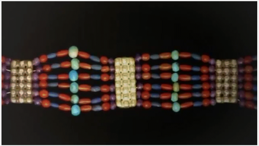
Example of high status Egyptian jewelry of those times
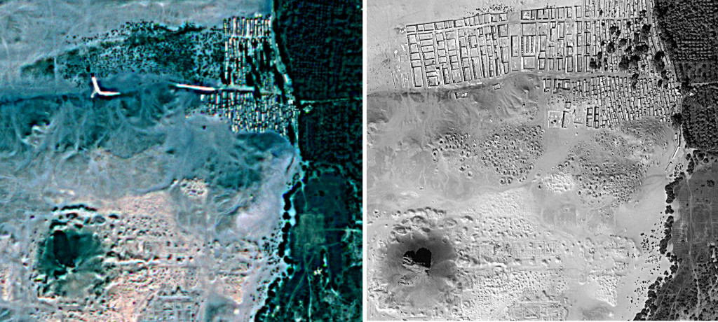
Tanis
Tanis is widely known to have been a principal city in Ancient Egypt, it even functioned as the capital city over several centuries. Tanis has even featured in a series of films featuring a somewhat unconventional, but often successful, archaeologist named Indiana Jones.After again proceeding with the aid of space satellite remote sensing Dr Sarah Parcak (aka @indyfromspace) and colleagues, have made important discoveries in relation both to the location and to the street layout of this ancient city.
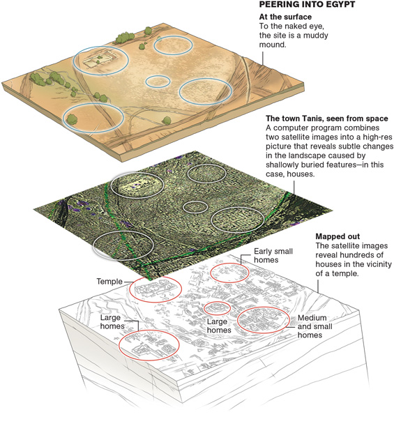
The full extent of the street plan of Tanis, once the capital of ancient Egypt, and a site made famous by the Indiana Jones film Raiders of the Lost Ark, has also been more completely revealed ~ and appears to suggest a scale some four times greater than had previously been imagined.
Thanks to satellite facilitated imaging techniques Parcak and her colleagues discovered an ancient network of streets and houses at Tanis, which are completely invisible from the ground.
To quote Sarah Parcak:-
"Above ground, you can't see anything," she says. "It's a silty mound with brown, muddy earth covering everything." After a few days of processing and peering at the images,
"this amazing map popped out," she recalls.
An ancient streetmap: A satellite image shows a once densely occupied city of Tanis to be littered with underground tombs. Buildings in ancient Egypt were constructed out of mud brick - the material is more dense than the surrounding soils, allowing imagery sourced from satellites orbiting above Earth to be captured in formats which show some detection of such differentials in density.
The outlines of structures completely invisible to human eyes, even those of trained archaeologists in their traditional ground surveys, are thus made visible.
This image of Tanis shows the difference between what the naked eye can see and the underground details that high-powered satellite remote sensing imaging can be demonstrated, through appropriate further interpretive processing, to be capable of discerning.

Seventeen Pyramids found in Egypt
It is believed that the tombs, (possibly pyramids), of some two hundred of Egypt's long succession of Pharaoh's remain to be discovered! Queens and princes themselves were also often entrusted - in line with beliefs in an afterlife - to entombment in pyramids.
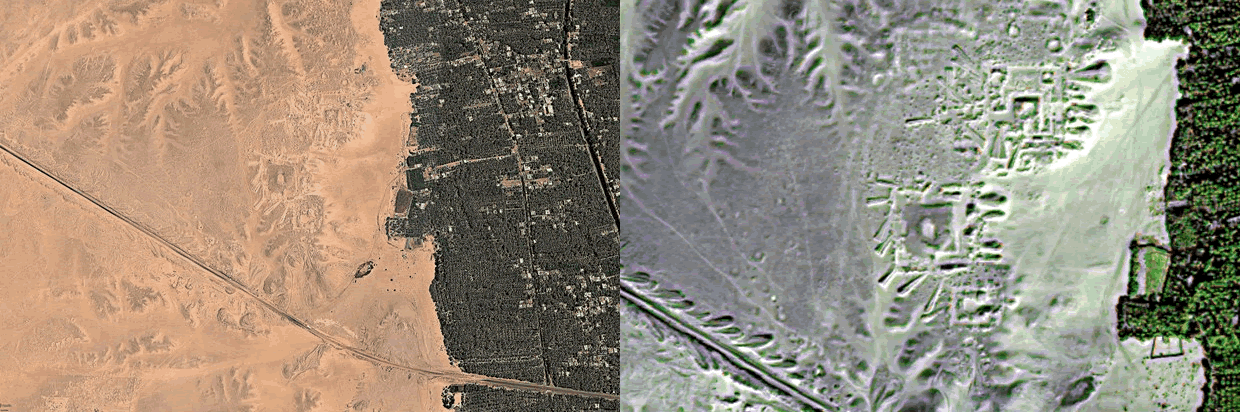
Images of proposed pyramids sites at Saqqara. Image on right after interpretive enhancement
In May, 2011, stories ran in national newspapers about finding the locations of ancient pyramids, settlements and tombs with the aid of satellite imagery and its interpretation.
The following selections come from a Daily Mail article:-
Satellites have helped locate 17 pyramids and 3,000 ancient settlements hidden underground in Egypt.
More than 1,000 burial sites were also discovered thanks to infra-red technology capable of probing beneath the desert sands from 450 miles above the Earth.
Astounded researchers on the ground have already confirmed that two of the pyramids exist - and they believe there are thousands more unknown sites in the region.
NASA-funded archaeologist Sarah Parcak said: "I couldn't believe we could locate so many sites. To excavate a pyramid is the dream of every archaeologist."
The NPR website featured content that was a little more explanatory about processes and a little more circumspect about proposed findings:-
"What these satellites do is they record light radiation that's reflected off the surface of the Earth in different parts of the light spectrum," Parcak explains to NPR's Rachel Martin. "We use false color imaging to try to tease out these very subtle differences on the ground."
Those subtle differences are an archaeologist's clues to what might lie under a rice paddy or a city street. "You just pull back for hundreds of miles using the satellite imagery, and all of a sudden this invisible world become visible," Parcak says. "You're actually able to see settlements and tombs - and even things like buried pyramids - that you might not otherwise be able to see."
What Parcak's team actually found was 17 structures that had a similar size, shape and orientation to other pyramids in the area. Initial excavations indicate that at least two of the structures are most likely pyramids, but Parcak warns, "we're not going to be able to say with a 100-percent certainty that they are pyramids until they're excavated."
That would be the fun part for most archaeologists - getting dirty. "You can theorize as much as you want about what you think you're seeing, but until you get out there and dig," Parcak says, "you can't tell exactly what it is."
The Amphitheatre at Portus
Dr Sarah Parcak is highly qualified as an Egyptologist but she has branched out, with marked success, into the interpretation of imagery sourced through space satellite remote sensing techniques.Dr Sarah Parcaks discoveries, as usually made in co-operation with highly qualified colleagues, have tended to bring her to public attention and to lead to requests for her assistance in other parts of the world than Egypt, and in relation to other time-periods than those of Ancient Egypt.
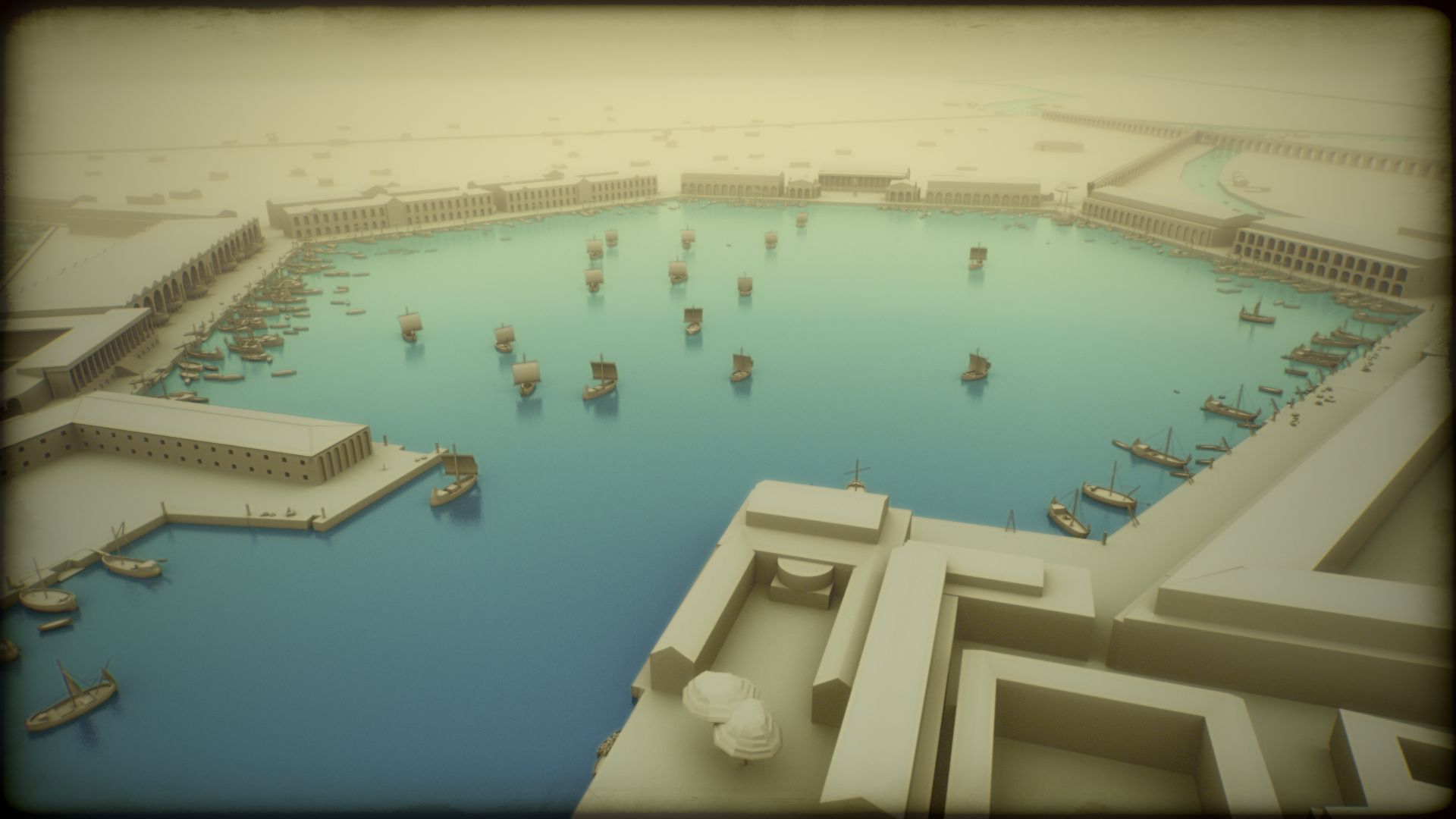
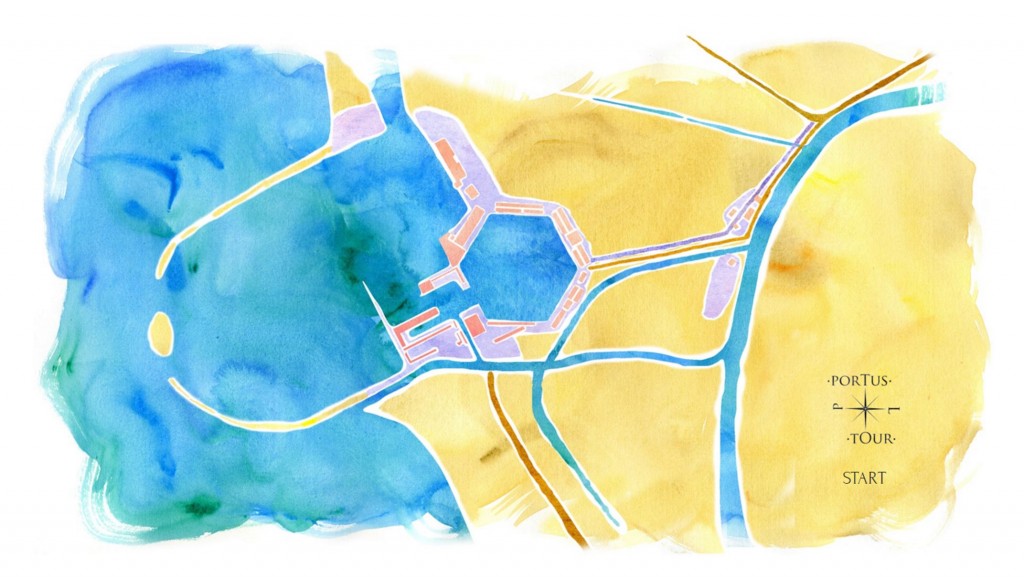
One such invitation to function as a - Space Archeologist - led to her being directly involved in a consideration of the lay-out of the Roman city at Portus.
Portus, located close to ancient Rome, had functioned as a very busy sea-port and as a notable transhipment center. Sea-going trading ships individually capable of carrying some 300 tons of cargo could dock there for loading and unloading.
The scale of operations at Portus can perhaps be gauged by a consideration of the following 3D interpretation of the harbour in its routine operations:-
When Dr Sarah Parcak was invited in she seemingly read up extensively on the literature which was available. Given what she had become familiar with she found herself able to report to archaeological colleagues at the University of Southampton, England, that she had made some interesting discoveries concerning houses and warehouses.
The archaeologists at Southampton had a long history of involvement with studying archaeology of ancient Rome. Sarah Parcak was, it seems, somewhat deflated when it was reported back to her that the archaeologists from Southampton knew about these posited discoveries - but had not published academic papers about them at that time.
She went back to the satellite remote sensing results and noticed something intriguing that she decided to make mention of to the colleagues at Southampton with whom she was liasing.
This mention seems to have been rather meekly made. Given the initial lack of success she had had in reporting findings to her Southampton-based colleagues previously Sarah Parcak maintains that she forwarded imagery without accompanying comment.
Images of Amphitheatre site ~ visible light
and near infra-red after processing
The feature outlined in the image derived from space satellite remote sensing and interpretive processing scales at about forty meters across. Walls some eight meters thick are held to be indicated as are what clearly seem to be roadways and gates.
It was reported back to Dr Sarah Parcak that when this latest of the satellite imagery research teams' discoveries was brought to the attention of the Professor at Southampton with whom they had been in communication "He fell out of his chair!"
To quote Sarah Parcak:-
"When I showed it to my colleagues, they got excited. They told me I had likely found the missing Amphitheatre of Portus."
The presence of an amphitheatre at Portus, when it served as a major sea-port in proximity to Ancient Rome, was regarded by archaeologists specialising in the Roman Era as having been a cultural requirement given the social realities of that place and time. It was seen as inevitable that some sort of arena capable of hosting gladiatorial combats and other spectacles would have been a necessity there in line with the presumable expectations of the numerous local population.
Researchers had long sought the location of this amphitheatre; but without conclusive success. Dr Sarah Parcak and her colleagues' discoveries were accepted as giving real indications as to where it had been sited.
The existence of an impressive canal, which was all of 90 meters or 100 yards wide, between Portus and the river Tiber was known about before Sarah Parcak and her colleagues became significantly involved in surveying Roman archaeology.
As a result of the existence of this canal Rome now lay some twenty five kilometers 'upriver' from Portus.
Portus operated both as a sea-port and as a transhipment center; such transhipment being for purposes of exportation as well as importation. Critically, this canal enabled vessels engaged in local transhipment to avoid having to enter upon often hazardous waters at the Tiber river's estuary in attempting to reach the city of Rome from Portus; or on their way back to Portus from Rome.
Dr Sarah Parcak and her teams' discoveries and conjectures, however, also included the possible identification of a smaller-scale canal whose route lay alongside, and at a little distance from, the course of the Tiber and could have facilitated navigation between Portus and Rome.
Considerable volumes of grains, wines and oils all figured significantly in this transportation by river and canal. Such a second channel could have been utilised to ease transport congestion between Portus and the great city that Imperial Rome then was.
It was even suggested that vessels could have "gone with the flow" down the Tiber and used the canal on their journeys towards Rome!
Archaeologists seem to believe that the harbour facilities were actually "tumbled down" by some Roman authority or other! This is thought to have happened, in times when the Empire was in evident decline, in order to deny those facilities to Gothic peoples who could have used them in pursuing further assaults on Rome.
Hopes are entertained that such deliberate "decommissioning" may have allowed much detail of archaeolgical and histroical significance to be preserved and to be better understood through further investigations.
Point Rosee, Newfoundland ~ "Vikings in North America?"
Viking's Unearthed (2016) - a BBC co-production with PBS, NOVA/WGBH Boston and France Television - offered an overview of discoveries at Point Rosee, Newfoundland which were, for a time, confidently said to have possible identification as the second known pre-Columbian example of iron ore processing in the New World.The term pre-Columbian is used in relation to both North America and South America to refer to those expanses of time prior to the widely accepted "Discovery of America" by Christopher Columbus in 1492.
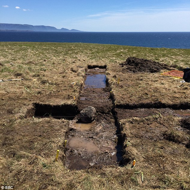
Excavation of this crude, but effective, bog-iron processing hearth
Who, then, might be held to be responsible for this - only the second known of example of iron ore processing in the Americas prior to 1492!
The first such find, located in the northernmost parts of Newfoundland and dating from approximately 1000 A.D., was established as having been associated with Norse or Viking peoples.
The Point Rosee site itself, located on a small grassy headland surrounded on three sides by the sea.
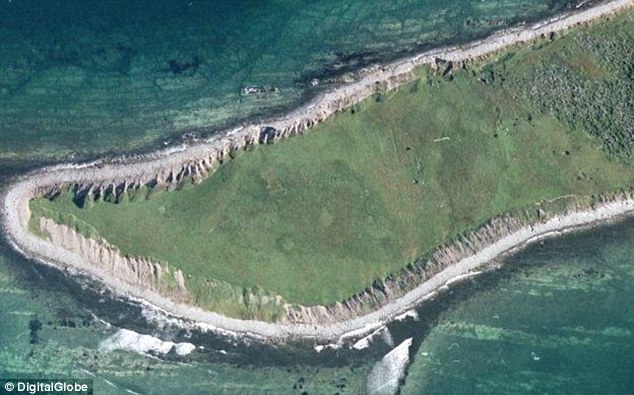
Satellite image by Digital Globe
The remnants of buried structures alter the surrounding soils, changing the amount of moisture they retain. This, in turn, affects vegetation growth. Using certain remote sensing techniques, variations in plant growth form a spectral outline of what was there centuries earlier. The Point Rosee images were intentionally taken during the fall, when the grasses in the area were particularly high, making it easier to see which plants were healthier; better enabled to absorb more water from the underlying soils.
The viability of those soils, in relation to vegetation growth, being affected by the remnants of long-buried underlying structures leading to subtle, but detectable differences in plant chlorophyll endowment.
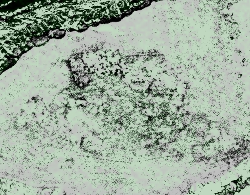
Satellite image by Digital Globe
The discoveries made during a three-weeks long period of excavation in the summer of 2015 seem to indicate that a second example of Norse or Viking settlement on Newfoundland could ~ possibly ~ also have existed on its south-western coasts, some three hundred miles to the south of the initial discovery at L'Anse aux Meadows.
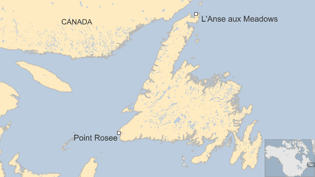
Point Rosee and the North American mainland:-
New Brunswick, Canada, lies to the west.
The USA coastline lies further to the south-west.
Sarah Parcak nevertheless insists, as of April, 2016, that Point Rosee remains possible, rather than proven, as a Viking or Norse settlement.
Sarah Parcak seems to have been reluctant to undertake these Viking-related studies when they were suggested to her by the BBC. She seems to have been disinclined to voluntarily associate herself with what has rightly or wrongly, since the initial discovery of a Norse or Viking site in northern Newfoundland in 1960, come to be regarded as a pursuit freely engaged in moreso by "amateurs" and "mavericks" than by serious archaeologists.
In a subsequent Yale University lecture she portrayed her attitude at the time as being one of - "I don't want to be one of these crazy people."
She eventually allowed herself to be persuaded to undertake these studies - financed by the BBC, National Geographic and others - whilst apparently having no real personal expectation that anything worthwhile was likely be discovered.
Sarah Parcak has become celebrated as a leading exponent of satellite archaeology from space, she nevertheless seems to fully accept that her best claims to archaeological authority lie in the field of Egyptology. Her own strong personal inclination to assume that the likelyhood of there being worthwhile findings in relation to viking activity was extremely low was reinforced by the similarly skeptical opinion she received from leading experts in the area of "the archaeology of the Vikings and of North America."
To quote a Sarah Parcak post on a National Geographic web page:-:-
"I did not want to do this project. I had to be convinced, mainly by Greg Mumford. Look my spouse, fellow archaeologist, and long-term Viking enthusiast.
See, archaeologists are specialists, and I'm an Egyptologist. That's just the hat I'm most comfortable wearing.
I knew enough about the Norse archaeology community to know that it's wildly different from what I'm used to. I have tremendous respect for people who have been working in the Norse world their whole careers, and I knew I had a lot to learn, quickly. The prospect of doing archaeology here made me deeply uncomfortable.
Another comment she made being:-
"We approached this very scientifically and with a lot of skepticism. If, if, if this could possibly be a Norse site, then the eyes of history would be on us and we wanted to do this right."
According to Sarah Parcak as reported on ideas.ted.com:-
"The site we found, called Point Rosee, would have been a good place to settle. It has streams for fresh water and a nearby beach for fishing - not to mention a landing area for ships. Beyond that, the site is close to the only valley in Newfoundland warm enough for agriculture. Could this site have been a Norse settlement? The bog iron processing certainly suggests it's a possibility. Right now, all we know for sure is that the site doesn't match other known cultures in the area; the only culture it matches at present is Norse. Still, we have a lot of work to do before I'm comfortable calling it a Norse site."
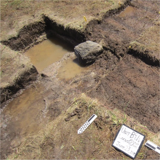
The iron processing hearth had a "stone lining"
The discoveries in relation to pre-Columbian iron-processing, together with the remaining ~ possibilities ~ of Viking settlement, that have so far come to light through this project can be said to have already greatly exceeded Dr Sarah Parcak's initial expectations!
Confirmation of Point Rosee as a Viking or Norse site may, or may not, soon be forthcoming as further meticulous archaeological investigations are scheduled to take place at Point Rosee in the summer of 2016,
According to Douglas Bolender, a Norse Archaeology specialist significantly involved in the investigations of 2015:-
"For a long time, serious North Atlantic archaeologists have largely ignored the idea of looking for Norse sites in coastal Canada because there was no real method for doing
so. If Sarah Parcak can find one Norse site using satellites, then there's a reasonable chance that you can use the same method to find more, if they exist. If Point Rosee
is Norse, it may open up coastal Canada to a whole new era of research."